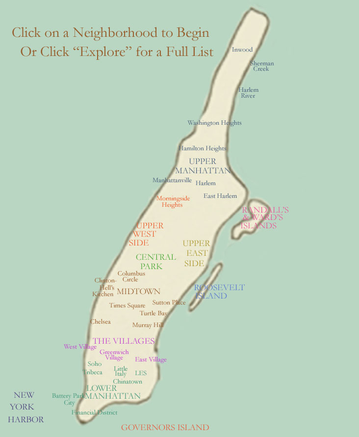
Support the Big Map!
Back to Big Map Home
Manhattan
Manhattan: Click On A Neighborhood To Begin Or Click "Explore" For A Full List

Explore Manhattan | Manhattan Feed

New York Harbor (Upper New York Bay) | Governors Island | High Line | Manhattanhenge | Fifth Avenue in Manhattan | Lower Manhattan | Midtown Manhattan | U Thant Island | Roosevelt Island | Central Park | Upper East Side | Randalls and Wards Island | Upper West Side | Upper Manhattan | Water Taxi Ride Around Manhattan

Inwood Washington Heights Hamilton Heights Harlem Manhattanville East Harlem Upper Manhattan Randalls and Wards Islands Morningside Heights Upper West Side Upper East Side Central Park Roosevelt Island Columbus Circle Clinton-Hell's Kitchen Midtown Manhattan Sutton Place Turtle Bay Times Square Chelsea The Villages Greenwich Village East Village West Village SoHo Tribeca Little Italy Lower East Side Chinatown Lower Manhattan Governors Island New York Harbor Murray Hill Sherman Creek Harlem River Battery Park City Financial District


Support the Big Map!

See what's new on the Big Map: 2025 United Airlines New York City Half Marathon; Domino Park in Williamsburg, Brooklyn; Hunter Island in Pelham Bay Park; Copán in Honduras; San Salvador's Iglesia El Rosario and Jardín Botánico La Laguna, Parque Nacional El Boquerón, Volcán de Santa Ana/Santa Ana Volcano and Suchitoto in El Salvador; Little Corona del Mar Beach in Orange County, California

Follow Bridge and Tunnel Club: @batclub

Inquire within about supporting the Big Map or acquiring Big Map images!

Click A Button For More
Explore Manhattan Manhattan Feed What is the Big Map? Citywide Get Out of Town

Sections

The Bronx
Brooklyn
Manhattan
Queens
Staten Island
Citywide
Out Of Town
What Is The Big Map?
Big Map Blog + RSS Feed


Support the Big Map!